
Google Earth boosts deforestation monitoring capabilities
Rhett A. Butler | mongabay.com | February 07, 2010
Google has taken a step towards boosting the deforestation monitoring capabilities the Google Earth Engine by contracting Massachusetts-based Clark Labs to develop an online version of its Land Change Modeler application.
Clark Labs' Land Change Modeler is a geographic information system (GIS) software package that enables users to estimate of historical deforestation rates and patterns, identify the drivers of deforestation, and project future deforestation scenarios and associated greenhouse gas emissions. The firm has been marketing the tool for use in projects under the proposed REDD program, a U.N.-backed climate change mitigation mechanism that aims to compensate developing countries for reducing emissions from deforestation and forest degradation.
According to a statement from Clark Labs, Google's philanthropic arm, Google.org, is looking to add Land Change Modeler functionalities to the Google Earth Engine, an online platform which leverages technologies developed by scientists to rapidly analyze and map vegetation, land use, and other environmental data. The engine, unveiled in December at climate talks in Copenhagen, initially launched with forest monitoring tools developed by Carnegie Institution for Science and IMAZON. These tools allow analysts to track changes in forest cover at extremely high resolution in near real-time in the Amazon. The project was coordinated and supported by the Gordon and Betty Moore Foundation.
"The objective of Earth Engine is to enable organizations such as Clark Labs to run their algorithms on-line, powered by Google's computational capacity, with easy access to massive earth observation data sets," said Dr. Amy Luers, Senior Environment Program Manager for Google.org.
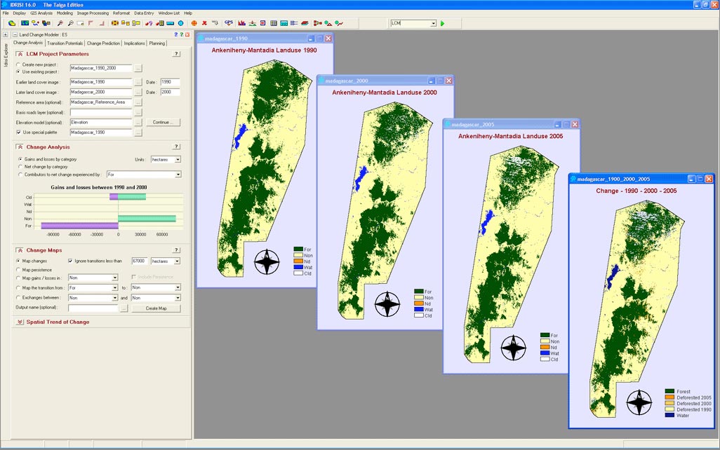
The first stage of a REDD project is the understanding of the historical trends in land use change. The Change Analysis tab in Land Change Modeler provides tools for the rapid assessment of change, allowing one to generate a series of evaluations of gains and losses, net change, persistence and specific transitions both in map and graphical form. This figure shows the historical pattern of change in the Ankeniheny-Mantadia Corridor in Madagascar. CLICK IMAGE TO ENLARGE.
Clark Labs says the Land Change Modeler is currently being used by "many governmental and non-governmental organizations" for REDD project development.
The Land Change Modeler is a software extension to ArcGIS, a suite of GIS software products generally used for viewing spatial data, creating maps, and performing spatial analysis.
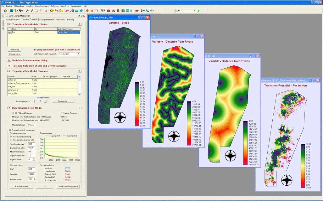
An important element for predicting future scenarios is understanding the underlying driving forces of change. The transition potential modeling facility in Land Change Modeler allows users to derive transition potential maps based on a set of driver variables, such as: slope, distance from roads, distance from markets, elevation, etc... These variables can be static or dynamic.CLICK IMAGE TO ENLARGE.


No comments:
Post a Comment