
Indonesia: Opening 2012 with disasters
With intensive rainfall since mid-December 2011 Indonesia is experiencing widespread disasters throughout the archipelago
Compiled by Awicaksono
Floods submerge farming areas in Banyumas
ANTARA News | January 2 2012
Banyumas, Central Java (ANTARA News) - Floods inundated hundreds of hectares of farming areas at several villages in Banyumas, Kalibagor and Patikraya subdistricts, in Banyumas District, Central Java Province, on Monday.
The floods had been triggered by the overflowing of Serayu River since Sunday (Jan 1), Sarwito, a local resident of Kalisube village, said here, Monday.
The floodwaters reaching a height of between 0.5 and 1 meter, inundated rice and corn fields.
Editor: Priyambodo RH
COPYRIGHT © 2012
Landslide buries three houses on Menoreh hill slope
ANTARA News | January 2 2012
Magelang, Central Java (ANTARA News) - A landslide hit the Menoreh hill area burying three houses located on the mountain`s slope at Selorejo, Ngargoretno, Salaman subdistrict, on Sunday.
Triggered by incessant heavy rains, the landslide occurred at seven points and forced 37 families to evacuate to safer places, the head of the Nahdlatul Ulama disaster mitigation task force`s Magelang chapter, Chabibullah, said here on Monday.
The landlside had also cut off several roads leaving three villages - Tegalombo, Sumbersari and Selorejo - isolated.
The disaster did not claim any human life but killed more than ten livestock.
A public graveyard was also buried by the landslide.
Editor: Priyambodo RH
COPYRIGHT © 2012
Earthquake shakes Ternate
ANTARA News | January 2 2012
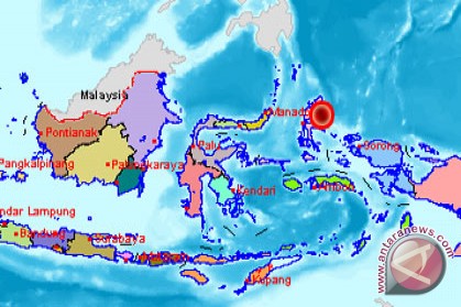 An earthquake measuring 5.1 on the Richter scale jolted Ternate, North Maluku. (BMKG)
Jakarta (ANTARA News) - An earthquake measuring 5.1 on the Richter scale jolted Ternate, North Maluku, on Monday at 4.07 am Western Indonesian Standard Time (WIB).
The quake`s epicenter was located at 2.14 degrees northern latitude, 128.30 degrees eastern longitude, and at a depth of 19 km below sea level.
The temblor was also located 183 km northeast of Ternate, 272 km southeast of Melonguane (North Sulawesi), and 322 km northeast of Labuha (North Maluku).
As a country located in the Pacific Ocean`s "Ring of Fire" of volcanoes and earthquakes, Indonesia is one of the world`s most disaster-prone countries.
One of the worst disasters hitting Indonesia in modern history was the deadly tsunami which devastated Aceh Province and Nias Island (North Sumatra Province) on December 26, 2004, which killed around 200,000 people and rendered about one million others homeless.
Earlier. in the wee hours of Monday, a magnitude-5.5 earthquake jolted Meulaboh, Aceh Province.
The quake`s epicenter was located at 4.45 degrees northern latitude and 96.39 degrees eastern longitude, and at a depth of 45 km, the Aceh meteorological, climatology and geophysics agency (BMKG) said.
A number of residents of Ujong Kalak village, Meulaboh, rushed out of their houses in panic when they felt the temblor.
Editor: Priyambodo RH
COPYRIGHT © 2012
Earthquake jolts Meulaboh
ANTARA News | January 2 2012
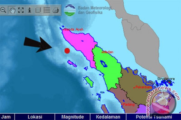 An earthquake measuring 5.5 on the Richter scale jolted Meulaboh, Aceh Province. (BMKG)
Meulaboh, Aceh (ANTARA News) - An earthquake measuring 5.5 on the Richter scale jolted Meulaboh, Aceh Province, on Monday at 01.09 am local time.
The quake`s epicenter was located at 4.45 degrees northern latitude and 96.39 degrees eastern longitude, and at a depth of 45 km, the Aceh meteorological, climatology and geophysics agency (BMKG) said.
A number of residents of Ujong Kalak village, Meulaboh, rushed out of their houses in panic when they felt the temblor.
"I was watching a film when I felt the temblor, in the beginning I stayed, but when other friends went out, I followed them," Andilia Farisma, a Meulaboh villager, said.
Head of the Aceh BMKG`s Observation Section Saiful Amri said the earthquake did not have potential to trigger a tsunami.
"An earthquake which has potential to cause a tsunami has a magnitude of at least 7 on the Richter scale or more, therefore we don`t have to panci," Saiful said.
As a country located in the Pacific Ocean`s "Ring of Fire" of volcanoes and earthquakes, Indonesia is one of the world`s most disaster-prone countries.
One of the worst disasters hitting Indonesia in modern history was the deadly tsunami which devastated Aceh Province and Nias Island (North Sumatra Province) on December 26, 2004, which killed around 200,000 people and rendered about one million others homeless.
Editor: Priyambodo RH
COPYRIGHT © 2012


No comments:
Post a Comment