
Amazon rainforest damage surges 67% in 2008
Rhett A. Butler, mongabay.com, December, 20, 2008
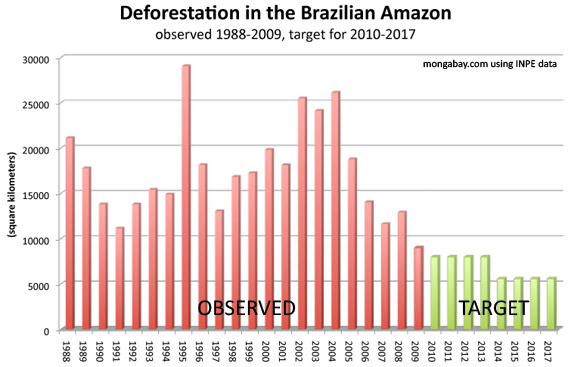
The area of rainforest in the process of being deforested — razed but not yet cleared — surged in the Brazilian Amazon during 2008, according to new figures released by Brazil's National Institute for Space Research (INPE). The announcement comes shortly after the Brazilian government reported a 4 percent increase in forest clearing for the year.
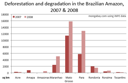
Using an advanced satellite system that tracks changes in vegetation cover INPE found that 24,932 square kilometers of Amazon forest was damaged between August 2007 and July 2008, an increase of 10,017 square kilometers -- 67 percent -- over the prior year. The figure is in addition to the 11,968 square kilometers of forest that were completely cleared, indicating that at least 36,900 square kilometers of forest were damaged or destroyed during the year. The sum does not include areas that may have been selectively logged for commercial timber.
Click to enlarge
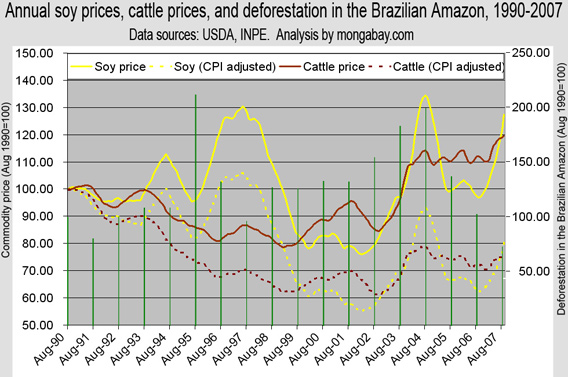
The surge in activity is attributed to the sharp rise in commodity prices over the past two years. While grain and meat prices have plunged since March, higher prices have provided an impetus for converting land for agriculture and pasture. Accordingly, the burning season of 2007 (July-September) saw record numbers of fires in some parts of the Amazon as farmers, speculators, and ranchers set vast areas ablaze to prepare for the 2008 growing season.
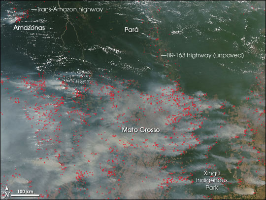
"I have never seen fires this bad," John Cain Carter, a rancher who runs the NGO Aliança da Terra, told mongabay.com last October. "The fires are even worse than in 1998's El Niño event... A huge area of the Xingu National Park was on fire, truly sickening as it is a sign of things to come."
Mato Grosso and Pará, states on Brazil's agricultural frontier, saw the highest levels of deforestation and degradation. Large swathes of forest land and cerrado (tropical savanna) in both states have been converted for large cattle ranches and mechanized soy farms in recent years.
New data
The mapping of Amazon forest degradation by INPE is a new development. The agency used imagery from Landsat and the China-Brazil Earth Resources Satellite (CBERS) to identify areas in the process of deforestation that are not accounted for under its PRODES monitoring system for deforestation. In addition to the change in degraded forest area between 2007 and 2008, the system detected 1,845 square kilometers of forest that went from 'degraded' to 'deforested', showing that 12 percent of the degraded area was cleared during the past year.
Avoiding deforestation
INPE says the new system will help Brazil meet deforestation reduction targets set earlier this month under the country's climate action plan by pinpointing areas where forest degradation is occurring. Identifying fronts for deforestation prior to actual clearing will allow authorities to take preventative measures, including determining the legality of the forest activities.
Deforestation presently accounts for more than half of Brazil's greenhouse gas emissions. As such, the government sees forest conservation as a means to reduce emissions, but believes industrialized countries should help pay for it. In August President Luiz Inacio Lula da Silva unveiled a $21 billion donation-based fund to finance conservation and sustainable development projects in the region. Norway has already committed a billion dollars to the initiative.
Brazil accounts for roughly sixty percent of the Amazon rainforest and the bulk of its deforestation. While less than 20 percent of the vast forest has been cleared, regional climate trends indicate that large swathes of the Amazon are increasingly susceptible to drought and fire. Coupled with continued deforestation, degradation, and fragmentation, some researchers say the Amazon is approaching a critical tipping point which could see more than half of the forest damaged or destroyed within a generation.
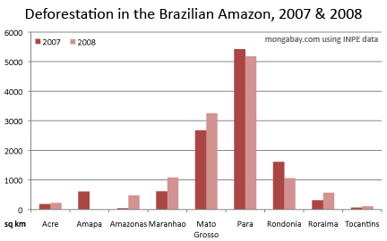
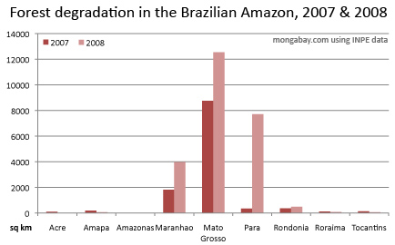
State figures for deforestation and degradation in the Brazilian Amazon.
On September 29, 2007, the Moderate Resolution Imaging Spectroradiometer (MODIS) on NASA's Aqua satellite captured this image of the southern Amazon, showing widespread fires (locations marked in red) in the state of Mato Grosso, Brazil. NASA image courtesy the MODIS Rapid Response Team, Goddard Space Flight Center.
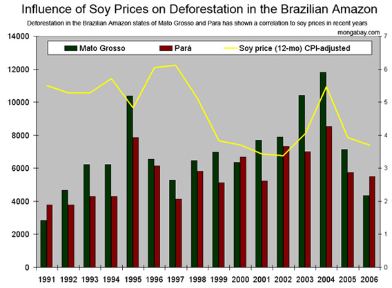
Influence of soy and cattle prices (CPI-adjusted, 12-month moving average) on deforestation in the Brazilian Amazon. Deforestation in the states of Mato Grosso and Para has shown a particularly strong correlation to soy prices in recent years. All figures in hectares (2.47 acres).
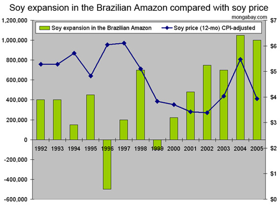
Soy acreage expansion in the Brazilian Amazon compared with the price of soybeans (CPI-adjusted, 12-month moving average). All figures in hectares.
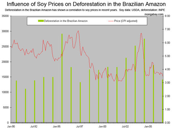
Influence of soybean prices (CPI-adjusted) on deforestation in the Brazilian Amazon. All figures in hectares (2.47 acres).
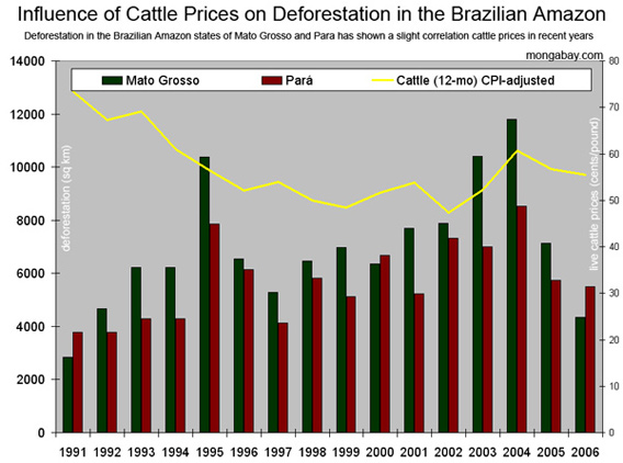
Influence of live cattle prices (CPI-adjusted, 12-month moving average) on deforestation in the Brazilian Amazon. While nearly two-thirds of Amazon clearing can be attributed to conversion for cattle pasture, deforestation in the states of Mato Grosso and Para has shown a only a slight correlation to cattle prices in recent years. This could be in part due to the use of cattle pasture for land speculation (land prices are rising faster than the value of cattle) and as a hedge against inflation and currency fluctuation. All figures in hectares (2.47 acres).
The recent surge in soy and cattle prices could be driving an increase in forest fires.


No comments:
Post a Comment